Puerto Vallarta, Mexico

Cruise port guide

Puerto Vallarta, Mexico

Puerto Vallarta pairs a walkable old town under a crown-topped church with a long, beach-lined bay and warm, reliable Pacific weather that peaks across the winter cruise season.

Facts verified Aug 12, 2026 · cross-checked across 16 sources

Photo by Patricia Veronica on Unsplash

To the tourist area
4.7 kmVerified
Taxi or local bus from the cruise pier
Country
Mexico
Currency
Mexican peso (MXN)
Language
Spanish
Time
Central Time (UTC−6)
Emergency
Dial 911 in an emergency
Verified Sourced Estimate

At a glance

Before you step off

Spanish is the working language here and the Mexican peso is the local currency, running around 17 to 18 to the US dollar, so converting a little cash on arrival covers taxis, markets, and tips. Power runs on Type A and B plugs at 127 volts, the same shape many North American travelers already carry, though anyone on a different standard should pack an adapter. The US State Department currently lists the destination at Level 2 (as of May 2026), exercise increased caution, which on a cruise day mostly means sticking to busy, well-trafficked areas and keeping an eye on your belongings.

Practical needs sit close to the port. A pharmacy is within roughly 320 meters and a clinic, Medicos de la bahia, within about 385 meters, so minor issues are easy to sort without straying far. The savvy move is to settle currency and a plug adapter before you step off, then keep the day loose and local rather than over-planning it.

The crew’s read, written from the verified facts in this guide.

What to do

The top 10 things to do in Puerto Vallarta, Mexico

The 10 that earn your hours first, and 2 more below them, ranked.

Our Lady of Guadalupe Church Must see

Photo: Another Believer · CC BY-SA 4.0

№ 1 of 12

Our Lady of Guadalupe Church

~20 min 5 km from the pier taxi Free

The crown-topped bell tower here is the image most people picture when they think of Puerto Vallarta, and the church sits right in the old town a short walk inland. Step inside for a few quiet minutes, photograph the ornate crown from the plaza, then move on. Locals call it the cathedral, though it is really the parish of Our Lady of Guadalupe.

Nothing planned yet

Add something from the list or the map and your day will appear here.

    What to eat

    Know the local table

    Coastal Jalisco cooking at full strength: fish grilled over wood coals, raw seafood cured bright with lime, tacos in every direction. Much of the best of it is cooked outdoors within earshot of the surf, and grazing is the right approach.

    Puerto Vallarta eats like coastal Jalisco: the day's catch cooked zarandeado-style over a wood fire, ceviche and aguachile sharp with citrus and chile, birria, and tacos carved off the spit. Seafood leads, shrimp done a dozen ways, and much of it comes off beachfront stalls and street carts. Prices climb the moment there's a sea view, so the value play is to graze the carts and markets and save the splurge for one proper sit-down meal. Portions run generous, service is unhurried, and a cold drink is never far.

    Pescado zarandeado

    Photo: El Nuevo Doge · CC0

    dish

    Pescado zarandeado

    Whole fish butterflied, marinated, and grilled over wood, the signature of this coast.

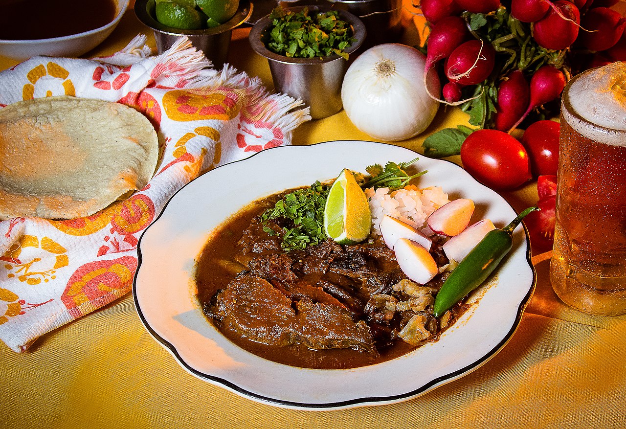
    Birria

    Photo: Carloscurielfotografo · CC BY-SA 3.0

    dish

    Birria

    A rich slow-cooked chili stew from Jalisco, served with consomme and warm tortillas.

    Aguachile

    Photo: Photo.MarioVG · CC BY-SA 4.0

    dish

    Aguachile

    Raw shrimp cured in lime and green chili, a Pacific-coast staple eaten fresh.

    Tacos al pastor

    Photo: T.Tseng · CC BY 2.0

    dish

    Tacos al pastor

    Spit-roasted marinated pork shaved onto small tortillas with a little pineapple.

    No photo yet

    drink

    Raicilla

    A regional agave spirit distilled in the Jalisco highlands behind the bay.

    When to sail

    December through February is the weather window, with dry days, a typical 84°, and not one storm in those months across 45 seasons.

    Every cell below is computed from 3,653 days of observations and 45 hurricane seasons. Color is the month's weather verdict, and each number is the measurement behind it. Whales: Dec–Mar.

    Our call: November through April.

    January, written out

    January opens the port's prime season, and it shows in every part of the day. Afternoons sit near 79°F, nights ease to about 64°F, and the water holds around 78°F, warm enough to get into without a flinch and comfortable enough to linger. Rain barely registers at roughly 44mm for the whole month, so a shore day rarely gets cut short by weather, and the long stretches of sun make it easy to plan around a single outing or several. This is low-drama, dependable time to be ashore, the kind of month where the forecast is rarely the reason to change plans.

    One date shapes the calendar. Año Nuevo falls on January 1, a public holiday when many shops and offices close or keep short hours. Plan anything ticketed or errand-like around it, and lean on the beaches and the waterfront, which keep no office hours and stay just as inviting whether or not the town is running a full schedule.

    February is about as dependable as the port gets, a prime-season month that asks very little of your planning. Highs sit near 81°F, lows settle around 63°F, and the sea stays close to 77°F, warm enough for an easy swim. Rain is almost an afterthought at roughly 16mm across the month, so the day is yours to shape without a backup plan, and clear skies are the rule rather than the exception. The mild nights make the evenings as pleasant as the afternoons, and the dry air keeps walking comfortable even in the sun.

    Watch for Día de la Constitución, a public holiday that can trim opening hours at shops and offices around the date. It rarely touches the outdoors, so a beach morning or a slow walk along the water carries the day even when businesses run short schedules. If you need anything ticketed or store-bought, handle it early and keep the rest of the day loose.

    By March the port is dry and bright, deep in its prime stretch. Highs run about 83°F, nights hold near 63°F, and the water sits around 77°F, while rainfall is negligible at roughly 7mm for the month. It is a comfortable window for time outdoors, with little chance the weather rewrites your plan, and warm days that stop short of the heavier heat still to come. The dry air makes for easy walking, and the reliably clear skies mean you can commit to an outing without a rain contingency.

    The month carries Natalicio de Benito Juárez, a public holiday that may shorten hours at shops and offices near the date. Time any paid attraction or errand around it. The beaches and waterfront stay open regardless, and with warm water and steady sun, the coast is the natural default for a day ashore even when the town runs a lighter schedule.

    April is the warm, dry peak of the prime season, and the heat is the day's main character. Afternoons reach about 86°F, nights stay mild near 65°F, and the sea is around 76°F, with rainfall down to a trace at roughly 1mm across the month. Shade and water breaks matter more than an umbrella here, and the midday sun is the thing to manage rather than any chance of rain. Mornings and late afternoons are the most comfortable hours to be out and moving.

    Two public holidays land in the Easter period, Jueves Santo and Viernes Santo. Both can close or shorten businesses and draw local crowds to the coast, so start early, keep the day flexible, and expect the beaches to be lively rather than quiet. It is a festive, busy stretch, and planning around the holidays, rather than against them, makes for the smoothest day ashore.

    May runs hot and dry, closing out the prime run before the rains arrive. Highs push to about 88°F, nights sit near 68°F, and the water warms to around 81°F, the most inviting swim of the dry season. Rain stays minimal at roughly 3mm, so heat, not weather, is the thing to manage. Hydrate, seek shade through the middle of the day, and let the warm sea do the cooling, which it does well at this temperature. The early hours are the most comfortable for anything active.

    Día del Trabajo is the public holiday to note, and it can shutter shops and offices for the day around the date. The coast stays open throughout, and the warm water makes beach time the natural move on a slower day in town. Handle any errands or paid sites ahead of the holiday, and treat the water as the reliable centerpiece of the day.

    June marks the turn toward the wet season, a shoulder month that bridges the dry stretch and the summer rains. Days still reach about 88°F, but nights hold warmer near 75°F, the sea climbs to around 84°F, and rainfall picks up to roughly 105mm. Showers tend to build later in the day, so plan anything outdoors for the morning and keep the afternoon loose enough to wait out a passing storm. The humidity is noticeably higher than in spring, and the landscape begins greening in response. No public holidays fall this month, so the calendar is clear. The trade-off is the weather itself. It is warmer, wetter, and quieter than the dry season, with a bathwater sea for anyone who does not mind a shower. Time an outing for the morning, treat the afternoon as flexible, and June rewards you with warm water and thinner crowds.

    July sits deep in the rainy season, and the pattern is consistent enough to plan around. Highs settle around 84°F while nights stay muggy near 77°F, and the sea is warm at about 86°F. Rain is the headline at roughly 324mm for the month, typically arriving as heavy, later-day downpours rather than all-day gray. Mornings are usually the clear window, so aim outdoor time early and treat an afternoon shower as part of the rhythm rather than a disruption. The humidity is high throughout, so pace yourself in the heat.

    There are no public holidays to plan around this month, which keeps the calendar simple. The upside of the wet months is a soft, green landscape and a warm ocean, with fewer visitors than the busy dry season brings. A well-timed morning ashore, with rain cover in the bag, still makes for a full and comfortable day.

    August is the wettest stretch of the year, the peak of the summer rains. Afternoons hold near 85°F, nights stay warm around 76°F, and the sea is at its warmest, about 88°F. Rainfall runs heavy at roughly 367mm, usually arriving as strong evening storms rather than steady daytime rain. The air is humid from morning on, so the earlier hours are the most comfortable for anything active, and the warm water is a genuine draw for anyone who plans around the showers.

    No public holidays land this month, so the calendar stays open. The practical play is the same as high summer. Use the clearer mornings for anything outdoors, carry rain cover, and lean into the warm water when the heat builds. It is humid and lush, and a passing storm rarely lasts the whole day, so a morning ashore followed by a flexible afternoon works well.

    September stays firmly in the rainy season, with the warmest water of the year to show for it. Highs sit near 86°F, nights stay warm around 75°F, and the sea reaches roughly 89°F. Rain remains substantial at about 281mm, mostly in later-day bursts, so the morning is again the safe window for anything outdoors. The humidity is high and the landscape is at its greenest, a reward of sorts for planning around the afternoon showers.

    The month carries Día de la Independencia, a public holiday marked widely across the country. Expect shortened business hours and a festive, busier feel around the date. Plan errands and paid sites around it, keep the day flexible for showers, and let the warm ocean and green surroundings carry the rest. It is a lively time to be in port, and working with the holiday rather than against it makes for the easiest day.

    October is the shoulder month on the way out of the rains, and conditions trend in your favor as the month goes on. Days run about 86°F, nights ease to near 73°F, the sea holds around 87°F, and rainfall eases to roughly 92mm, noticeably drier than the peak of summer. The landscape is still green from the wet season, but the odds of a clear afternoon improve as the storms thin out, which makes for a more forgiving day ashore than July or August offered.

    No public holidays fall this month, so the calendar is uncomplicated. Mornings remain the safest bet for outdoor plans, with the warm water an easy default for the rest of the day. It is a transitional month, warm and lush but drying out, and a little flexibility with timing goes a long way toward a full day in port.

    November swings back into the prime season, and it is one of the more balanced months to be in port. Highs settle near 83°F, nights cool pleasantly to about 69°F, and the sea stays warm around 83°F, while rainfall drops to roughly 27mm as the dry stretch returns. The air is comfortable rather than heavy, the nights are genuinely mild, and the reliable sun makes it easy to commit to a full day ashore without a rain plan.

    Día de la Revolución is the public holiday to note, and it can trim hours at shops and offices around the date. Otherwise little stands between you and a full day out, with warm days, mild nights, and a sea still warm enough for an easy swim. Handle anything ticketed or store-bought ahead of the holiday, and the balance of the day is yours to spend as you like.

    December closes the year in the prime season, with dependable, comfortable weather for a day ashore. Afternoons sit near 81°F, nights ease to about 66°F, and the water holds around 80°F, with rain light at roughly 24mm. These are steady conditions, warm without the heavier heat of late spring, and the low rainfall means the forecast is rarely the reason to change plans. The mild nights keep the evenings as easy as the afternoons.

    Navidad is the public holiday to plan around. Many shops and offices close or keep short hours near the date, and the coast tends to fill with local visitors in a festive stretch. Start early, keep plans flexible, and expect a warm, busy waterfront rather than a quiet one. If you handle errands and paid sites ahead of the holiday, the beaches and the water carry the day.

    How the score works

    The score blends weather (50%), fares (30%) and crowds (20%) from this port's daily weather record and the sailings we track. Fares use each month's median per-night rate, so one outlier sailing can't move it. Missing signals drop out and are named; thin data shows a dash, never a fake verdict; a cat-3+ hurricane history caps a month's score.

    Jan Prime Whale season

    89/100

    Weather · 50%98
    Value (fares) · 30%100
    Calm (crowds) · 20%47
    • A typical January has 30 dry days and feels like 83°.

    • Whale-watching boats sell out on ship days, so reserve ahead.

    • Peak humpback season, with mothers and calves in Banderas Bay through January and February.

    • Whale-watching boats sell out on ship days, so reserve ahead.

    • Peak humpback season continues in Banderas Bay.

    • Sailing late in the month? Whale tours thin out after the season closes March 23.

    • Humpback season winds down; the official season ends March 23.

    • An early-November call lands in festival crowds. Check the current year's event schedule.

    • Day of the Dead fills the Malecón with altars and giant catrinas around November 1–2.

    • Book a morning whale-watching boat on ship days, and expect dense crowds near the Guadalupe church December 11–12.

    • Humpback whale season opens mid-December (official season December 8 – March 23); Guadalupe processions fill downtown December 1–12.

    Sea
    78°
    Bright sun
    9h
    Port calls
    27
    See January sailings

    Verdicts: Prime = under 15% wet days (1 mm+) and feels-like 88°F or less; Rainy = 40%+ wet days; Stormy adds a cat-3+ hurricane pass on record; the rest are Shoulder.

    What a day ashore feels like

    10-yr daily record

    March runs 2% wet days; August flips to 99%. May feels like 97° once humidity counts, muggy 0% of days. January is a dry 83°. Never cold: 76° even in April, 89° by September.

    JFMAMJJASOND80°90°100°50%100%feels likeseachance of rain
    All 3,653 days, one cell per day

    dry 100+ mm

    Wettest day in the record: 119 mm (2021-08-28). Record: 2015-01-01 → 2024-12-31, ERA5 reanalysis for 20.6220, -105.2280.

    Hurricane risk, storm by storm

    51 passes · NOAA tracks

    Every named storm passing within 100 nautical miles since 1980, 51 of them, and not one between November and April. The worst, Patricia (2015), was a category 5 at its peak and came within 47 nm.

    JanFebMarAprMayJunJulAugSepOctNovDec198020022024Newton (1980), cat 0, 100 nmIrwin (1981), cat 0, 70 nmOtis (1981), cat 1, 38 nmAdolph (1983), cat 0, 16 nmNewton (1986), cat 1, 89 nmEugene (1987), cat 1, 20 nmDebby (1988), cat 0, 57 nmPriscilla (1989), cat 0, 100 nmDouglas (1990), cat 0, 58 nmDiana (1990), cat 0, 85 nmUnnamed (1991), cat 0, 96 nmVirgil (1992), cat 0, 38 nmWinifred (1992), cat 0, 94 nmCalvin (1993), cat 2, 22 nmGert (1993), cat 0, 27 nmRosa (1994), cat 2, 95 nmBoris (1996), cat 0, 79 nmDolly (1996), cat 0, 69 nmHernan (1996), cat 0, 9 nmJavier (1998), cat 0, 7 nmUnnamed (1998), cat 0, 92 nmMadeline (1998), cat 1, 72 nmGreg (1999), cat 0, 61 nmNorman (2000), cat 0, 20 nmJulio (2002), cat 0, 90 nmKenna (2002), cat 4, 52 nmIgnacio (2003), cat 0, 100 nmOlaf (2003), cat 0, 45 nmJohn (2006), cat 2, 82 nmLane (2006), cat 2, 63 nmAndres (2009), cat 0, 98 nmBeatriz (2011), cat 0, 97 nmUnnamed (2011), cat 0, 86 nmJova (2011), cat 2, 18 nmBud (2012), cat 0, 33 nmManuel (2013), cat 0, 15 nmCarlos (2015), cat 0, 30 nmPatricia (2015), cat 5, 47 nmJavier (2016), cat 0, 90 nmPilar (2017), cat 0, 56 nmLorena (2019), cat 1, 28 nmNarda (2019), cat 0, 5 nmPriscilla (2019), cat 0, 93 nmHernan (2020), cat 0, 49 nmDolores (2021), cat 0, 70 nmEnrique (2021), cat 1, 74 nmNora (2021), cat 1, 10 nmOrlene (2022), cat 3, 89 nmRoslyn (2022), cat 4, 55 nmBeatriz (2023), cat 0, 92 nmLidia (2023), cat 4, 35 nm

    Sunshine

    hours per day

    April is the bright season, with 12 sun-hours a day against 9 in January.

    9J10F11M12A12M11J11J10A10S10O10N9D

    Wind never makes this list here. Daily maximums average a light 7–10 km/h all year, with no tender-cancellation risk. Day length barely changes at this latitude. The grey cap on each sunshine bar is the daylight the sun didn't fill, and that's all the chart it needs.

    What a night costs, month by month

    fare spread per night

    Typically $95 a night in January, the year’s low on the books; May runs about $374.

    Box = middle 50% of nightly balcony fares · median line · dashed mean · dots are outliers or single sailings (grey count = sailings). Per person, taxes in.

    Computed from 3,653 daily observations (2015-01-01 → 2024-12-31, nasa-power-merra2) · storm tracks: ibtracs-v04r01, 1980–2024 · wet day = 1 mm+. Averages smooth year-to-year swings, so check the day-by-day record before you book.

    Ships & sailings, who’s here, and for how much

    all upcoming, 413

    All 413 upcoming sailings we track that call at Puerto Vallarta, Mexico. Priced sailings are placed below on the day they’re here using their lowest cabin fare, per person per night; the month-by-month matrix above covers the next 12 months.

    413 sailings 17 cruise lines 41 ships busiest month: December, 49 calls busiest day: Dec 31, 3 ships in port typically $123 pp/night 9 confirmed drops ▼

    The departure board. Each dot is one sailing on the day it calls here; height is its per-person, per-night fare, and bigger dots are longer cruises. A falling dot is a confirmed price drop. Its tail is the size of the cut, from the old fare down to today’s. A gold ring marks a fare well below that line’s typical here. Click a dot for its details; drag across the chart to zoom to a date range, or double-click to reset.

    Fares are the lowest cabin fare we track per sailing, taxes included, and they move daily, so click through for the live price history. Counts cover the lines we track.

    Before you go

    Questions, answered

    What is there to do at Puerto Vallarta cruise port?
    Our Lady of Guadalupe Church, The Boy on the Seahorse and Los Arcos top our ranked list of things to do. Each one shows the walk or ride to reach it, the cost, and how long it needs, and you can build your own day stop by stop in the planner above.
    How do I get to downtown Puerto Vallarta from the cruise terminal?
    The usual way in is by taxi or local bus from the cruise pier. The center is about 4.7 km from the berth.
    What money should I bring ashore?
    The local currency is the Mexican peso (MXN). Carry a little in cash, since small vendors often don't take cards.
    What's the worst month to visit Puerto Vallarta?
    The stretch to skip if you want dry decks is July, August and September, the rainy season, when it's wettest and most humid. Every month is scored on weather, crowds and fares in the when-to-sail scoreboard above, so you can weigh the rain against fares and crowds.
    Where are the essentials, such as pharmacy, clinic?
    Pharmacy: within about 300 m. Clinic: Unidad De Medicina Familiar No. 170 Aramara within about 200 m.
    What if the day runs long, or I miss the ship?
    If a tour sold by your ship runs late, the ship waits; book independently and that safety net is gone, which matters most on long outings. If you do miss it, go straight to the port agent. The name and number are on your daily program and posted at the terminal, and they coordinate catching the ship at its next call. Carry a photo of your passport ashore separate from the original, agree the fare back before you get in the taxi, and start toward the pier well before your leave-by time.
    What's the cruise ship schedule for Puerto Vallarta, Mexico?
    The When to sail section plots every sailing we track that calls here, 413 through the year ahead, each one placed on the day the ship is in port and coloured by cruise line, so you can see which ships are scheduled and when. It's the published schedule from the lines we track, not a live position tracker.

    Based on 16 sources, last verified Aug 12, 2026.

    Open data: weather & climate © Open-Meteo (CC BY 4.0); maps & places © OpenFreeMap and OpenStreetMap contributors (ODbL); storm history from NOAA IBTrACS; reference from Wikidata, Wikipedia & Wikivoyage (CC BY-SA). Photos are credited individually.